
Oklahoma Buy Land · A practical land buying guide
How to check rural water availability on land in Oklahoma.
A water line nearby does not always mean you can get a tap. Here is how to find the right district and get useful answers before buying land.
Watch the walkthrough
Rather watch than read?
Follow along with my video guide, then use the step-by-step images below when you are ready to research a property.
Watch on YouTube ↗Before you buy
“Utilities nearby” is only the beginning.
Before buying land in Oklahoma, verify whether rural water is actually available for the tract. A line on a map, a neighbor with service, or a listing description may not tell the full story.
This guide walks through the process I use: find the property, research the possible provider, and contact the district to confirm availability, requirements, and costs.
01 · Locate
Find the actual tract.
Gather a map, a nearby address, road names, and landmarks that make the property easy to identify.
02 · Research
Identify the provider.
Use OWRB’s mapping resources to look for water-system information and possible service areas.
03 · Confirm
Ask about a new tap.
Get a property-specific answer from the district, including costs, timing, and any conditions.
Step 1
Find your property.
Start with Google Maps, ID Land, onX, or the county assessor’s map. Find the actual tract, not just the address shown on the listing.
Vacant land may not have an assigned street address. A listing address such as “1 E 1180 Road, Okemah” may be a placeholder rather than a location a utility office can search.
Once you locate the land, write down:
- A nearby neighbor’s real address.
- The road the property fronts.
- The nearest road or highway intersection.
Save a map with the property boundary marked so you can send it to the district later.

Step 2
Identify the rural water district.
Open the Oklahoma Water Resources Board website in another tab so you can keep this guide open beside it.
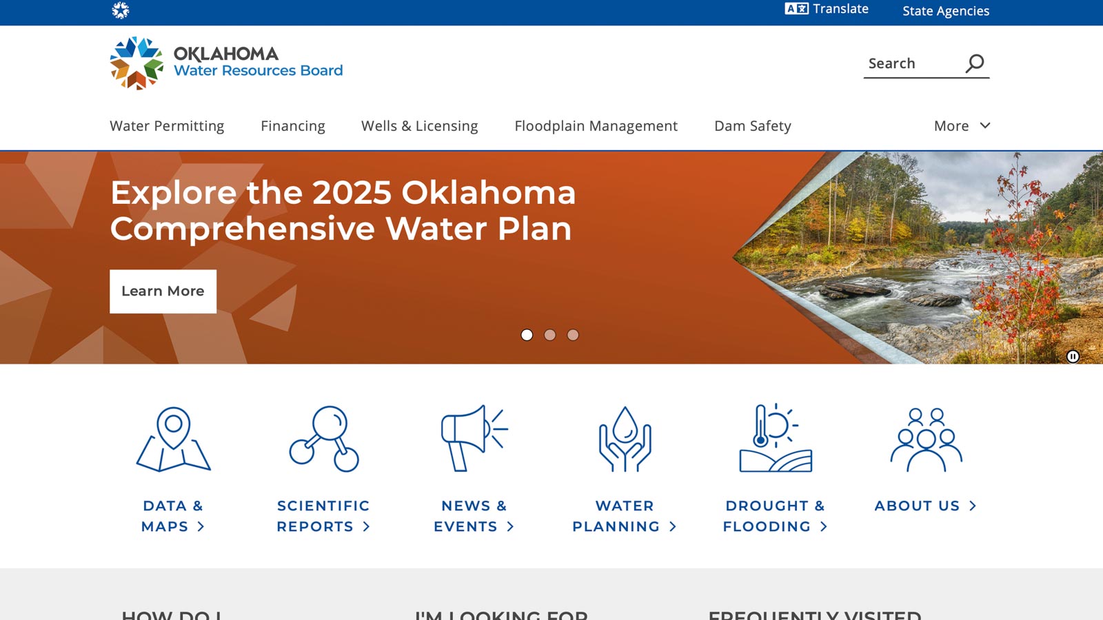
Find Data and Maps, then Interactive Maps. This is the starting point for identifying possible providers and mapped infrastructure around your property.
The website’s layout may differ from the screenshot. The direct link below takes you to the current Interactive Maps page.
Step 2A
Open the General Viewer.
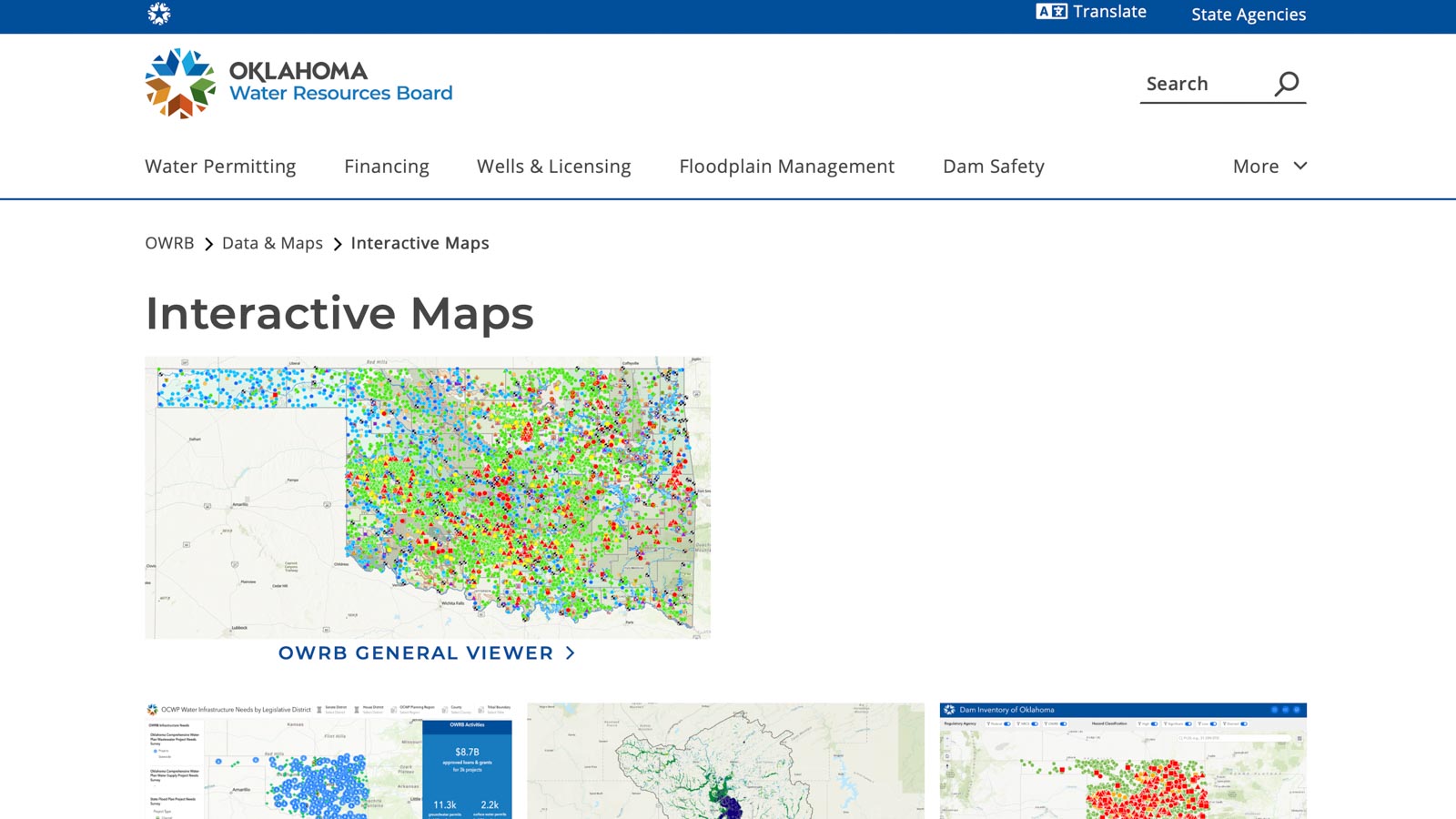
On the Interactive Maps page, select OWRB General Viewer.
Keep it open in a separate tab. You will use the viewer to locate the tract, check available water-system layers, and identify the district to contact.
OWRB now links to a newer viewer, so the location and appearance of its tools may differ from this walkthrough’s screenshots.
Step 2B
Find your property in the viewer.
Use the viewer’s search tool to enter an address, or zoom in manually using roads and nearby towns as reference points.
For this walkthrough, I am using approximately 30 acres I own near Okemah. The property does not have an assigned street address.
I can find it by searching a neighbor’s address or by following Highway 27 to E 1180 Road, then locating the tract along that road.
Compare the viewer with your property map before moving on. Make sure you are checking the correct side of the road and the correct tract.
Step 2C
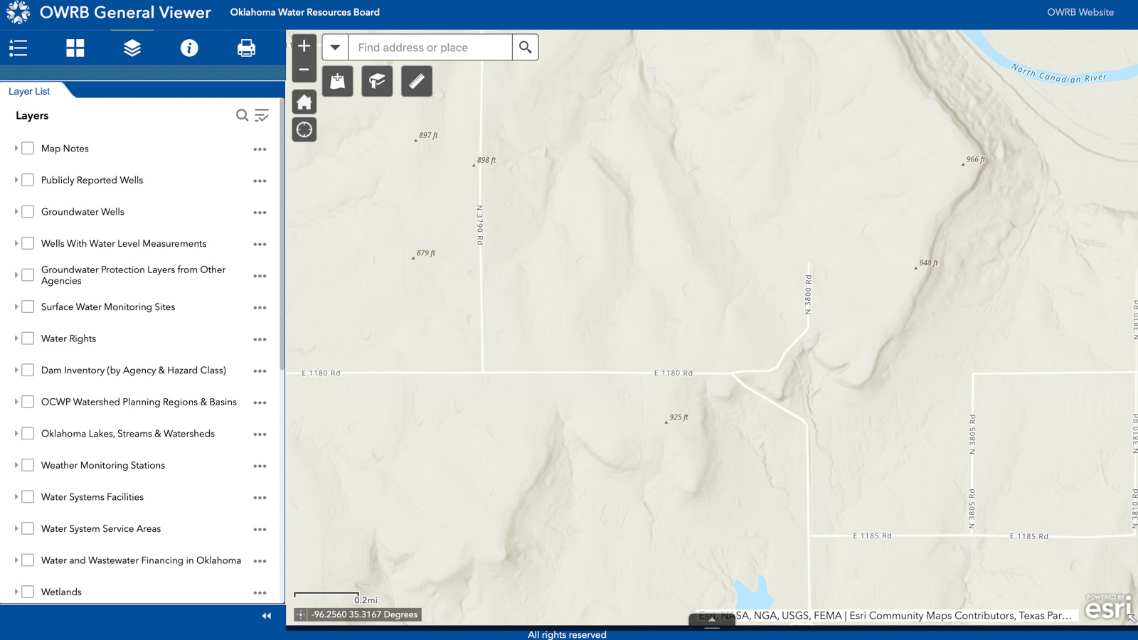
Locate the tract and turn on water layers.
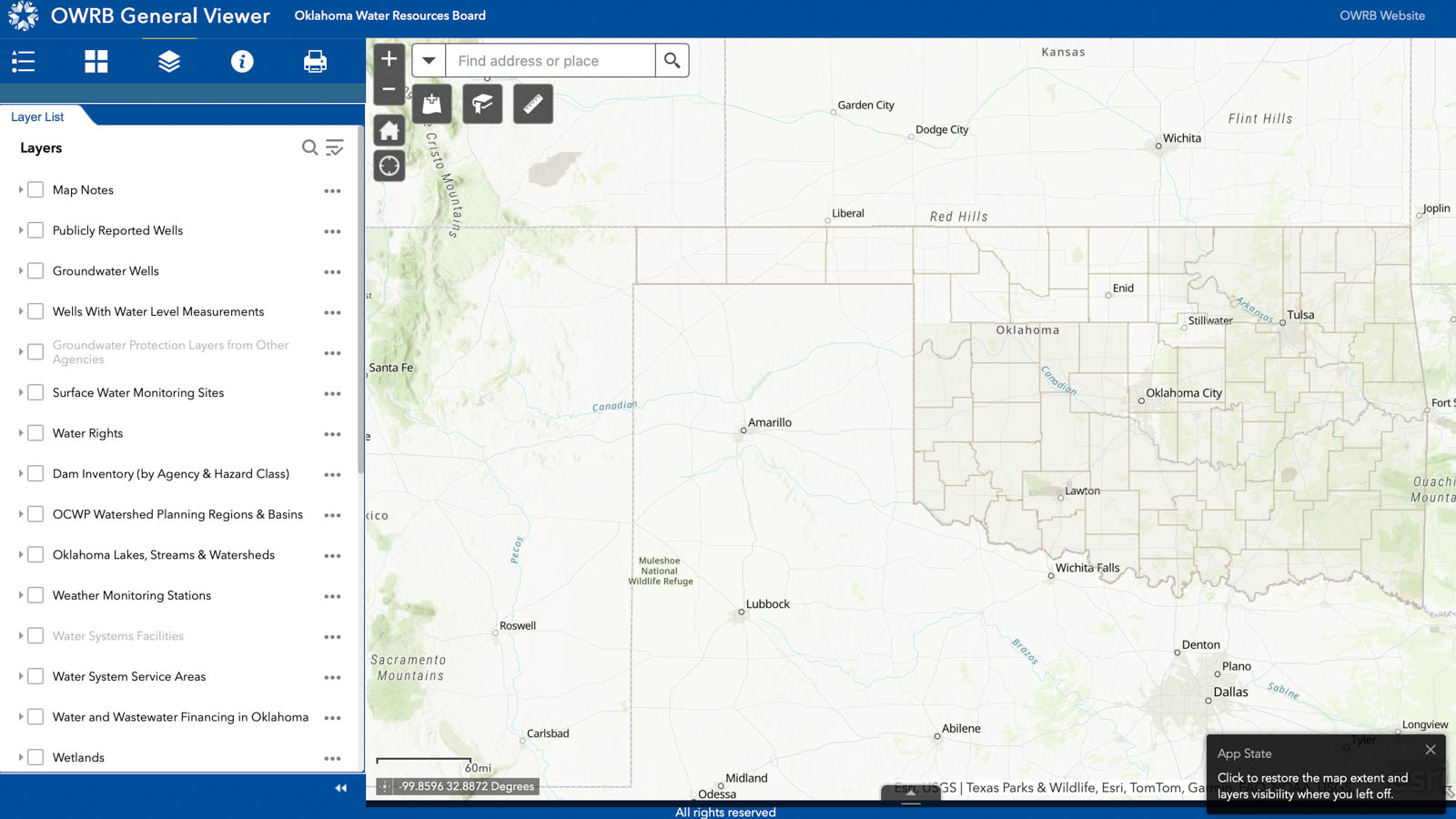
Once you find the property, open the layer list. Turn off unrelated layers so the map is easier to read. You may need to scroll through the list to find everything that is selected.
In the version shown here, the layer is called Water System Facilities. Look for water-system facilities, pipelines, and service-area layers in the current viewer.
Expand layer groups when needed and zoom closer if features do not appear. Keep your property location in view as you adjust the map.
Step 2D
Click a water line, if one appears.
In this example, the mapped water lines appear in yellow. Select a line near the tract to see any available details, such as the provider’s name and the reported pipe diameter.
For my example property, the map showed a 2-inch line along the road and identified Okfuskee County RWD #2.
You may see 2-inch, 4-inch, 6-inch, or other pipe sizes. Record the information, but do not use pipe size alone to decide whether a new tap can be approved.
A line on the map is a lead to follow, not confirmation of service. Ask the district about current capacity and whether it can serve your specific property and intended use.

Step 2E
If no water lines show up, check service areas.
No visible line does not automatically mean there is no rural water. The map may not show every line, and some information may be incomplete or outdated.
Look for the water-system service-area layer. Select the area covering or surrounding your tract and write down the provider names shown.
In my example near E 1180 Road and Highway 27, the service-area information pointed me toward Okfuskee County RWD #2. Multiple results can appear, so confirm which provider actually serves your location.
Service-area shading is a research starting point. It does not guarantee that the district can issue a tap for the property.

Step 3
Find the district’s contact information.
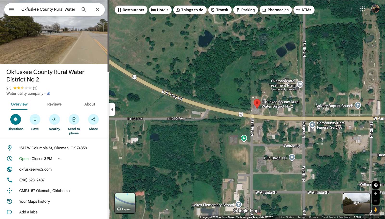
Copy the provider’s name from the map and search for it online. A regular Google search or a business search in Google Maps can help you find its website and office number.
Check the county and district number carefully. Similar names can lead you to the wrong office.
The screenshot below shows the Google Maps business listing I used for Okfuskee County RWD #2. Use the district’s current official contact information when available, since numbers and office details can change.
Step 4
Call the rural water district.
When I call a rural water district, I try to make the property as easy as possible for the person on the phone to identify.
A nearby neighbor’s real address is often the most useful starting point. Once they find that address, I can explain where the tract sits in relation to it.
Tell them what you plan to do with the property. One home, several future lots, livestock use, or another project may involve different questions.
Ask who handles new-service requests and what they need to review the tract. Have the property information below ready to email.

Make it easy for them to help
What I send to the rural water district.
Parcel IDs, coordinates, and legal descriptions can help. In my experience, a known nearby address and a clear map often make the conversation much easier.
My test is simple: could I verbally guide someone from the nearest town to the property using main roads? If I can explain it clearly, I am more likely to get a useful answer.
- A map image with the property boundary marked
- A nearby neighbor’s real address
- The road name and nearest cross streets
- The county and parcel ID
- Township, range, and section, if available
- A GPS pin and brief written directions
- The proposed use and number of taps needed
The conversation that matters
Ask more than “Is there water nearby?”
Be clear, concise, and respectful of their time. Give the office enough information to answer questions about your specific tract.
Availability
Can I get a water tap?
Ask whether the district can approve a new tap for this property and your intended use. Find out whether a site visit, application, or additional review is needed.
If you plan to split the land, ask about the number of taps you need. One available tap does not answer the question for multiple future lots.
Timing
What does approval actually secure?
Ask for written confirmation where possible. Find out whether availability is only an estimate, whether it can be reserved, and what payment or paperwork is required.
Ask about expiration dates, installation timing, and whether approval transfers to a new owner. Do not assume today’s answer remains valid indefinitely.
Total cost
What will connection cost?
Request the current fees for membership, the tap, meter installation, deposits, and any required line extension or road crossing.
Ask where the meter would be installed and who pays to run the private service line from the meter to your future home or other improvements.
Ask which side of the road the line is on. A crossing may require boring beneath the road or another approved method. A bore goes under the road; it is different from cutting an open trench across it.
As one historical example, a rural water district near Henryetta quoted me $2,000 per bore for a paved two-lane road on February 26, 2026 . That was a specific quote, not a statewide rate or a current estimate for your property.
Bring the answers together
Before you rely on rural water, confirm the details.
- The correct provider for the exact tract.
- Whether a new tap can be approved for your proposed use.
- The required application, payment, and review process.
- The meter location and any extension or crossing work.
- The full estimated cost and installation timeline.
- Any conditions or expiration dates on written confirmation.
If service is not available, ask what would be required before assuming the issue is an easy fix. A possible future extension is different from an approved connection.
Work with someone who works with land
You do not have to figure it all out alone.
I love land, own land, and work through these questions with buyers and sellers. Water availability is one part of understanding whether a property fits what you want to do.
Whether you are buying rural acreage, looking for a homesite, or considering a lot split around Broken Arrow, Tulsa, or elsewhere in Oklahoma, I would be glad to help you ask the right questions.
Where can I learn more about buying land?
Start with my Oklahoma land buying guide for help with access, utilities, surveys, and other due diligence questions.
How can I check legal access?
Read my legal access guide . Being able to physically reach a property does not, by itself, confirm legal access.
Do you help sellers?
Yes. I help Oklahoma landowners evaluate and market their properties. Visit my selling vacant land page to learn more.
Do you have a team?
I work with a client services team to help guide transactions from pending to sold.
Can I ask about a specific property?
Absolutely. Send me a message with the property location and what you are considering, or email corbett@ourokrealty.com .
Keep researching
More resources for Oklahoma land buyers.
- The complete Oklahoma land buying guide
- Confirming legal access
- Checking electric availability
- Confirming utilities
- Understanding whether land is buildable
- Checking septic and sewer availability
- Checking internet and cell service
- Checking utility easements
- Gas and propane availability
- OWRB Interactive Maps
Map reference: OWRB’s public water supply viewer information explains the general nature and limitations of its service-area and pipeline data. Confirm current availability, requirements, and costs directly with the provider.